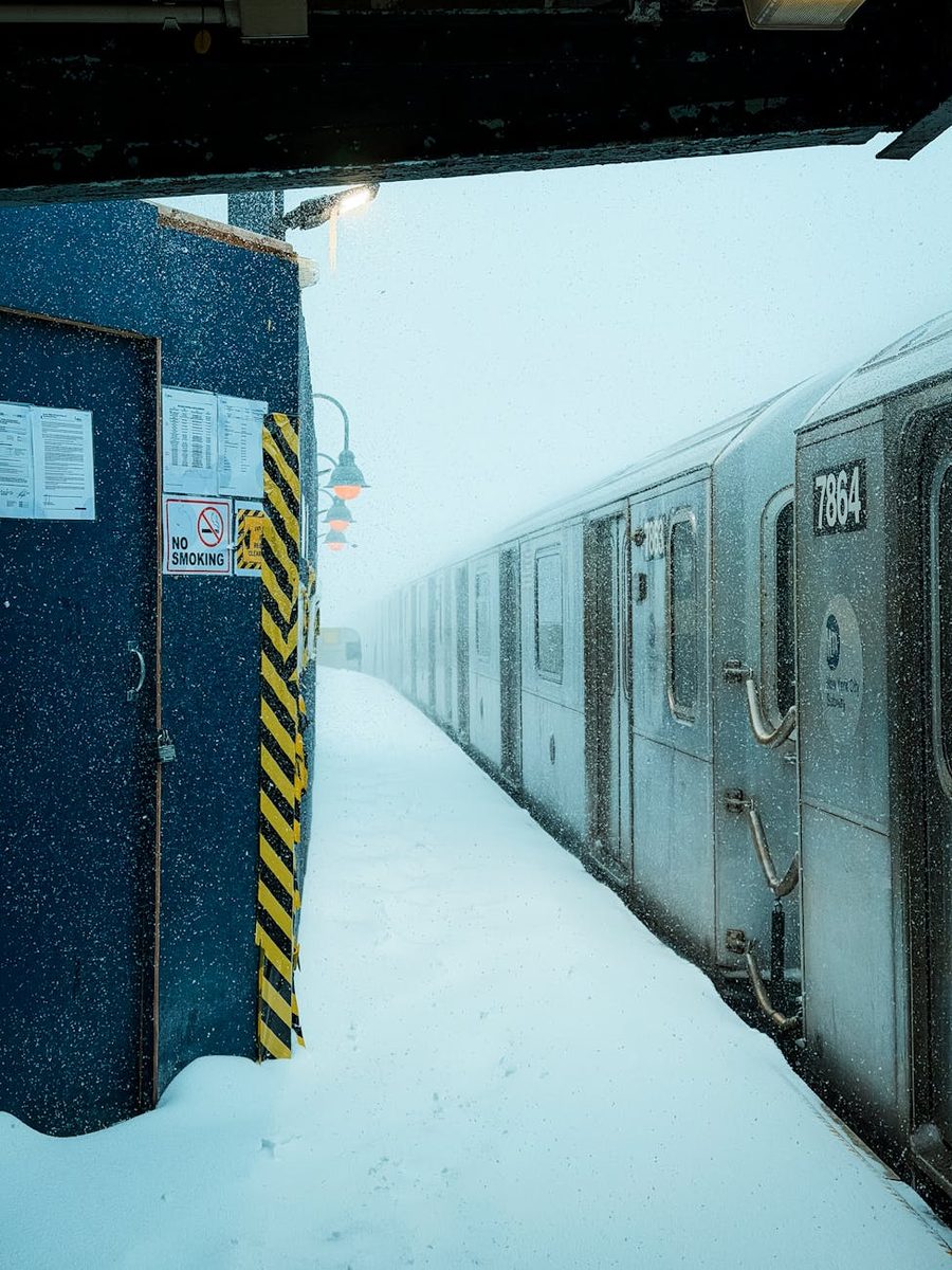
Benjamin Franklin
Fictional AI pastiche — not real quote.
"Nature, it seems, hath delivered unto the I-95 corridor what no Act of Congress could contrive — a unanimous agreement to stay home."
Historic blizzard dumps 2+ feet across Northeast; 600,000+ power outages as recovery efforts begin amid ongoing travel chaos
4 days ago: Storm peaks with 2+ feet snow across Northeast; outages hit 600,000New here? Follow stories to track developments over time. Create a free account to get updates when stories you care about change.
In This Story
Exploring all sides of a story is often best achieved with Play.
Fictional AI pastiche — not real quote.
"Nature, it seems, hath delivered unto the I-95 corridor what no Act of Congress could contrive — a unanimous agreement to stay home."
Sign up to generate historical perspectives on this story.
Two rounds, two personas, one winner. You set the crossfire.
Watch two AI personas debate this story using real evidence
Choose one persona for each side of the debate
Select debater for this side:
Make your prediction before the referee scores
Pick the question both personas must answer in the final round
Debate Oracle! You called every round!
Sharp Instincts! You know your debaters!
The Coin Flip Strategist! Perfectly balanced!
The Contrarian! Bold predictions!
Inverse Genius! Try betting the opposite next time!
Can you match the quotes to the right people?
-- ?
The federal agency responsible for weather forecasts, warnings, and observations across the United States.
The agency responsible for regulating civil aviation and managing air traffic in the United States.
The federal agency responsible for coordinating disaster response and recovery across the United States.
Cumulative snowfall exceeded 2 feet along NYC-Boston corridor with 30.7 inches in Lyndhurst NJ and 19 inches in NYC. Power outages reached 600k+ customers; NJ, RI, PA, CT added emergency declarations with travel bans. 8,000+ flights cancelled, 22,000 delayed amid 600-mile blizzard warning zone and coastal flooding.
Snowfall totals reached 14 inches on Staten Island and 9.3 inches in Central Park as blizzard warnings continued through evening. New York City enacted full travel ban, closed schools (first snow day since 2019), and reported widespread power outages; over 400,000 customers affected region-wide.
The storm rapidly intensifies through bombogenesis off the Eastern Seaboard, delivering 1 to 2 feet of snow along the I-95 corridor with wind gusts up to 70 mph. Over 7,000 flights are cancelled. The FAA imposes ground stops at JFK, LaGuardia, and Newark. Coastal flood warnings extend from Delaware Bay to Cape Cod with 2-to-4-foot storm surge.
The NWS upgrades to blizzard warnings for New York City, Long Island, southern Connecticut, and coastal New England. Governors Hochul and Sherrill declare states of emergency in New York and New Jersey. New Jersey activates 3,400 road crew workers.
Models shift dramatically, showing the storm tracking closer to the coast with much heavier snow totals. The NWS issues winter storm watches across the Northeast.
The National Weather Service begins tracking a potential coastal storm system, initially characterized as a routine February weather event.
A separate bomb cyclone strikes the eastern United States less than a week after the January storm, further straining snow-removal budgets and utility crews in the Northeast.
A massive winter storm spanning 2,300 miles strikes from the Four Corners region to Maine, killing more than 50 people and leaving hundreds of thousands without power. More than 20 governors declare states of emergency.
Discussed by: National Weather Service Weather Prediction Center, Fox Weather, Washington Post Capital Weather Gang
The storm meets or exceeds forecast totals of 18 to 24 inches across the urban corridor, with isolated higher amounts near the coast. Snowfall rates exceeding two inches per hour combined with 70-mph wind gusts produce whiteout conditions and widespread power outages lasting into midweek. Travel remains impossible Monday, and the weight of heavy, wet snow causes significant tree damage and structural strain. This is the scenario most forecasters consider likeliest based on model consensus as of February 22.
Discussed by: NWS ensemble model spreads, meteorological community discussions
The storm's center tracks slightly farther offshore than forecast, producing a sharper snowfall gradient that drops totals significantly for inland areas while coastal zones still take a beating. Cities like Philadelphia see 6 to 10 inches instead of 18-plus, easing travel disruption. Coastal flooding and wind damage remain significant, but the inland infrastructure impact is more manageable. This scenario reflects the outer edge of model uncertainty.
Discussed by: NWS coastal flood warnings, Delaware and New Jersey emergency management agencies
Storm surge of 2 to 4 feet coincides with high tide cycles late Sunday night or early Monday morning, producing moderate-to-major coastal flooding from Delaware Bay through Cape Cod. Low-lying communities in southern New Jersey and Delaware experience water levels among the highest on record. Beach erosion compounds damage from the January storms. This scenario is most acute for specific coastal areas rather than the broader region.
Discussed by: FEMA, state emergency management agencies, utility company projections
The combination of heavy, wet snow and sustained high winds brings down trees and power lines across the region, producing outages affecting hundreds of thousands of customers. Restoration takes days, particularly in suburban and rural areas with overhead power lines. Given that this is the third major winter storm in a month, utility crews are already fatigued and equipment is stretched thin. FEMA's existing emergency declarations allow federal resources to flow, but the cumulative strain on infrastructure becomes a political issue.
A massive blizzard struck the Eastern United States from January 22 to 24, 2016, dumping a record 27.5 inches of snow on New York City's Central Park—the highest total ever recorded there. Approximately 103 million people were affected, 33 million fell under blizzard warnings, and the storm killed at least 48 people across multiple states.
Nearly 12,000 flights were cancelled, over 300,000 customers lost power, and travel bans were imposed across multiple states. Recovery took nearly a week in some areas.
Jonas set the benchmark for modern nor'easter preparedness in the Northeast, prompting cities to refine their storm response protocols and pre-positioning strategies for subsequent major storms.
The February 2026 nor'easter is forecast to produce snowfall totals in the same range as Jonas along the I-95 corridor, with similar population exposure and blizzard warning coverage. Jonas provides the closest recent comparison for what the Northeast may face.
From January 6 to 8, 1996, a powerful blizzard struck the Eastern United States, affecting over 100 million people across 26 states. Snowfall totals reached one to four feet in major metropolitan areas, including significant accumulations in New York City, Philadelphia, and Washington, D.C.
The storm caused 154 deaths and an estimated $3 billion in damage. A rapid thaw following the blizzard produced severe flooding across the mid-Atlantic, compounding the destruction.
The 1996 storm demonstrated how a winter event's secondary effects—particularly rapid snowmelt flooding—can rival the initial damage, informing how emergency managers plan for storm aftermath.
The 2026 nor'easter arrives after a winter with repeated heavy snow events that have already saturated the region. If a warm-up follows, the 1996 pattern of post-blizzard flooding could repeat, making the total snowpack a factor beyond this single storm.
From March 12 to 15, 1993, a massive cyclone struck the entire Eastern Seaboard from Florida to Maine, producing hurricane-force winds, tornadoes in the South, and heavy snow across 26 states. The storm killed 318 people and caused approximately $2 billion in damage, affecting more than 100 million people.
Air travel was shut down across the eastern third of the country for the first time in modern history. Some areas in the Appalachian Mountains received over four feet of snow.
The 1993 storm led to significant improvements in winter storm forecasting and the NWS warning system, establishing the template for how the agency communicates multi-hazard winter events.
Like the 1993 storm, the 2026 nor'easter involves a rapidly intensifying cyclone producing simultaneous threats—heavy snow, high winds, and coastal flooding—across a vast geographic area. The forecasting improvements born from 1993 are exactly what allowed the NWS to issue warnings days in advance for this storm.