
Pull to refresh
Logo
Amsterdam's 3D seismic survey publishes first images of the rock that could heat the city

Amsterdam's 3D seismic survey publishes first images of the rock that could heat the city

Built World

SCAN releases time-migrated pictures of 130 square kilometres beneath the Amsterdam Metropolitan Area; the depth version and any drilling decision are still ahead

Overview

Updated 57 minutes ago

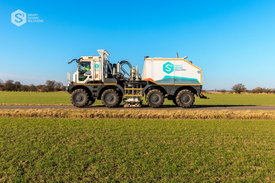
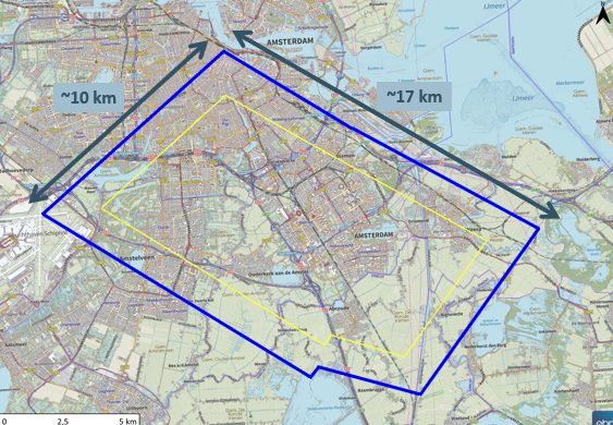
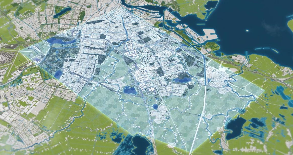
For four months, convoys of trucks with vibrating plates underneath drove through Amsterdam after dark, stopping every 20 metres to shake the ground and record what came back. On 19 November 2026, the SCAN program published the first processed images from that work: a three-dimensional picture of the deep rock under about 130 square kilometres of the Amsterdam Metropolitan Area.

The target is the Slochteren sandstone, a layer earlier studies judged technically suitable for geothermal heat production. What is public now is a time-migrated image, which shows structures but places them at approximate depths; a depth-migrated version is due in early 2027. Amsterdam has a sharper map of a possible heat source, not yet a confirmed one.

Why it matters

Amsterdam and Vattenfall want geothermal heat flowing by 2031. This survey decides where, or whether, they can drill.

Questions about this story

Free account needed to ask — your question is kept and asked for you right after sign-up. Answers are public.

No questions yet — be the first to ask.

Key Indicators

130 km²
Subsurface mapped in 3D
Usable coverage came out larger than SCAN had anticipated.
160 km²
Survey working area
Spread across nine municipalities, from Amsterdam to Haarlemmermeer.
~20,000
Source points
Vibration points used to send signals into the subsurface.
7.5 TB
Seismic data recorded
Raw data volume from geophone sensors in and around the city.
9
Municipalities covered
Amstelveen, Amsterdam, Diemen, Ouder-Amstel, De Ronde Venen, Wijdemeren, Stichtse Vecht, Gooise Meren, Haarlemmermeer.
2031
Target year for first geothermal source
Goal set by the City of Amsterdam, Vattenfall and EBN.

Voices

Curated perspectives — historical figures and your fellow readers.

Sign up to generate historical perspectives on this story.

People Involved

Organizations Involved

Timeline

2021 November 2026

9 events Latest: Today
Tap a bar to jump to that date
  1. Time-migrated 3D data published

    Today Release

    Pre-stack time migration results appear on the NLOG subsurface portal.

  2. Follow-up work in the Amsterdamse Bos

    Exploration

    Additional measurements begin in the Amsterdamse Bos as part of the wider survey effort.

  3. Lessons learned presented

    Statement

    SCAN tells a geothermal forum that processing continues and first results are due early Q4.

  4. National drilling campaign completed

    Exploration

    SCAN finishes exploration drilling at eight sites across the Netherlands.

  5. Fieldwork ends

    Exploration

    Roughly 20,000 source points and 7.5 terabytes of data recorded; microphones removed.

  6. 3D survey begins

    Exploration

    Vibration trucks work Amsterdam's streets at night; a research well starts on Strandeiland.

  7. Research well at Ouderkerk aan de Amstel

    Exploration

    SCAN drills a research well to sample the rock beneath the region directly.

  8. Second 2D campaign

    Exploration

    A follow-up 2D survey adds coverage before the program commits to a full 3D campaign.

  9. First 2D seismic surveys

    Exploration

    SCAN shoots two-dimensional seismic lines in the region, the first pass at mapping its deep geology.

Scenarios

1

Depth-migrated dataset lands on NLOG in early 2027

Likely Resolves by Q2 2027

Discussed by: SCAN's own publication schedule and its May 2026 forum presentation

SCAN has said the Pre-Stack Depth Migration version follows the time-migrated release in early 2027, with an initial structural interpretation available on request. If it appears on that timetable, planners get depth-accurate positions for potential reservoirs and the project keeps its sequence toward siting decisions.

2

A geothermal production site is drilled in the Amsterdam region before 2031

Uncertain Resolves by End of 2031

Discussed by: City of Amsterdam, Vattenfall and EBN, which set the 2031 first-source goal

The partnership's stated aim is to have a first geothermal source in use by 2031, which requires selecting a location, securing permits and bringing in an operator. The new 3D data is the technical basis for that choice. Success would show up as a drilling permit or final investment decision for a production well inside the surveyed area.

3

Data shows the reservoir is weaker than hoped and the project stalls

Possible Resolves by End of 2028

Discussed by: No party has predicted this; it is the open risk in SCAN's own framing that results still have to be interpreted

EBN's survey team said the area around Amsterdam appears to offer opportunities, while cautioning that definitive results are still to come. If the depth-migrated data or a future test well shows the Slochteren sandstone is broken up, too thin or too permeable-poor at candidate sites, the 2031 target slips and heat networks keep looking for other sources.

Historical Context

3 moments from history that rhyme with this story — and how they unfolded.

2021–2022

SCAN's 2D surveys in the Amsterdam region (2021–2022)

Before committing to a citywide 3D campaign, SCAN shot two-dimensional seismic lines across the region. Those lines gave a coarse cross-section of the deep subsurface and pointed to the Slochteren sandstone as the layer worth pursuing.

Then

Established that the region's geology warranted closer, three-dimensional study.

Now

Set the sequence of escalating survey detail that culminated in the 2025 campaign.

Why this matters now

The November 2026 release is the third pass at the same rock, which is why SCAN can describe the new image as an improvement rather than a first look.

2023

Research well at Ouderkerk aan de Amstel (2023)

SCAN drilled a research well south of Amsterdam to obtain direct information about the rock at depth, complementing what seismic lines can infer from reflections alone.

Then

Gave the program physical ground truth at one point in the region.

Now

Fed into the case for a full 3D survey across the metropolitan area.

Why this matters now

Seismic images are interpretations of sound; a well is a measurement. The pairing is what any future production decision will rest on.

2026

SCAN's eight-well national drilling campaign (2026)

The program completed exploration drilling at eight sites around the Netherlands, part of a national effort to identify where geothermal extraction is technically viable.

Then

Produced well data across several different geological settings.

Now

Gives municipalities and heat companies a national picture to compare local prospects against.

Why this matters now

Amsterdam's survey is one piece of a countrywide mapping exercise, not a standalone experiment.

Sources

(8)