Logo
Daily Brief
Following
Why
Satellite Reveals Tsunamis Don't Behave As Scientists Thought

Satellite Reveals Tsunamis Don't Behave As Scientists Thought

NASA's SWOT captures first high-resolution view of Pacific tsunami, upending 50 years of wave theory

Overview

NASA's SWOT satellite caught a magnitude 8.8 Kamchatka earthquake's tsunami in unprecedented detail on July 30, 2025. The waves weren't behaving like a single stable swell—they scattered, interacted, and dispersed across the Pacific basin like nothing scientists expected from textbook models. For 50 years, researchers treated big tsunamis as 'non-dispersive,' meaning they travel as one coherent wave. That assumption just died.

The finding forces a rewrite of tsunami forecasting models used by NOAA to warn coastal communities. Traditional models underestimated how these waves break apart over distance, meaning real tsunamis might hit coastlines differently than predictions suggest. SWOT's 120-kilometer-wide scan captured what older satellites couldn't—a 2D snapshot of wave chaos rather than a thin 1D line. It's the difference between watching a storm from inside versus glimpsing it through a crack in the door.

Key Indicators

120 km
Observation swath width
SWOT's scanning width vs. older satellites' single-line tracks
45 cm
Peak wave height detected
Maximum tsunami height recorded 70 minutes after the quake
8.8
Earthquake magnitude
Sixth-largest quake since 1900; generated Pacific-wide tsunami
4
Tsunami events captured
SWOT has now detected tsunamis from Loyalty Islands, Greenland, Chile, and Kamchatka since 2023

People Involved

Angel Ruiz-Angulo
Angel Ruiz-Angulo
Lead Author, University of Iceland (Published groundbreaking SWOT tsunami analysis in The Seismic Record)
Diego Melgar
Diego Melgar
Co-Author, University of Oregon Seismologist (Analyzing SWOT data for tsunami modeling improvements)
Ben Hamlington
Ben Hamlington
NASA JPL Oceanographer, Sea Level and Ice Group (Leading NASA's sea level research and SWOT science applications)

Organizations Involved

NASA Jet Propulsion Laboratory
Federal Research Institution
Status: Leading U.S. operations for SWOT mission

JPL manages NASA's robotic space and Earth science missions, including SWOT's development, launch, and operations.

CNES (Centre National d’Études Spatiales)
National Space Agency
Status: Equal partner in SWOT mission

France's space agency co-developed SWOT's radar interferometer instrument and shares all mission data.

NOAA Center for Tsunami Research
Federal Research Center
Status: Integrating SWOT data into operational tsunami forecasts

NOAA's tsunami science arm develops forecast models that send alerts to coastal communities during tsunami events.

Timeline

  1. NASA Announces Model-Breaking Discovery

    Announcement

    JPL reveals SWOT data proves tsunamis scatter and disperse far more than existing models predict, requiring theory revision.

  2. Peer-Reviewed Study Published

    Publication

    Ruiz-Angulo, Melgar, et al. publish analysis in The Seismic Record documenting dispersive tsunami behavior.

  3. NOAA Begins Model Integration

    Research

    NOAA Center for Tsunami Research starts incorporating SWOT measurements to improve operational forecast models.

  4. SWOT Records Kamchatka Tsunami

    Observation

    70 minutes post-quake, SWOT captures 120-km-wide swath showing 45-cm tsunami with complex scattering patterns never seen before.

  5. Kamchatka M8.8 Earthquake Strikes

    Earthquake

    Sixth-largest recorded earthquake hits 136 km east-southeast of Petropavlovsk-Kamchatsky at 35 km depth. Pacific-wide tsunami triggered.

  6. Chilean Patagonia Tsunami Captured

    Observation

    SWOT observes tsunami in South Atlantic from M7.4 Chilean earthquake, detecting waves five hours post-quake.

  7. SWOT Data Officially Validated

    Mission Milestone

    SWOT Science Team completes validation of all data products, confirming measurement accuracy and reliability.

  8. Greenland Fjord Tsunami Observed

    Observation

    SWOT detects tsunami sloshing in Greenland fjord with 1.2-meter height differences across fjord walls.

  9. Science Operations Begin

    Mission Milestone

    After six months of calibration, SWOT enters 21-day orbital cycle at 890 km altitude for science data collection.

  10. First Tsunami Detection (Loyalty Islands)

    Observation

    SWOT captures first-ever 2D tsunami signature from M7.7 quake southeast of Loyalty Islands, about one hour post-earthquake.

  11. SWOT Satellite Launches

    Mission Milestone

    NASA-CNES joint mission launches from Vandenberg on SpaceX Falcon 9. Designed to survey 90% of Earth's water.

Scenarios

1

SWOT Data Becomes Standard in Tsunami Warnings

Discussed by: NASA JPL researchers, NOAA Center for Tsunami Research, academic oceanographers

NOAA integrates SWOT observations into operational tsunami forecasts within 2-3 years, complementing DART buoys with satellite 2D imaging. Future tsunami warnings incorporate dispersive modeling, improving coastal inundation predictions. Other nations adopt the technology. Follow-on satellites planned to ensure continuous coverage after SWOT's mission ends, potentially including GNSS-R constellations with 48 satellites providing 15-25 minute tsunami detection. This requires solving data latency challenges—SWOT currently takes hours to downlink, but real-time systems demand minutes.

2

Discovery Remains Academic Footnote

Discussed by: Technology skeptics, budget-constrained agencies

SWOT's findings reshape scientific papers but fail to change operational practice. NOAA determines that incorporating dispersive effects adds computational complexity without materially improving warning accuracy for most scenarios. Satellite coverage gaps—SWOT revisits the same location every 21 days—prove too sparse for reliable real-time detection. The $1.2 billion mission remains a research tool rather than an operational asset. No follow-on satellites get funded, and the breakthrough joins decades of tsunami research that never reaches the warning centers where it might save lives.

3

Satellite Constellation Revolutionizes Disaster Detection

Discussed by: Space agencies exploring multi-hazard monitoring, disaster response planners

SWOT's success catalyzes a paradigm shift beyond tsunamis. The same 2D altimetry detecting scattered tsunami waves reveals hurricane intensity, rogue waves, and ocean current changes. International space agencies launch a coordinated constellation of SWOT-like satellites, cutting revisit times from 21 days to hours. Combined with AI-powered analysis, the system provides near-real-time global ocean hazard detection. The technology spills into commercial sector—private satellite operators add ocean altimetry to their constellations, making space-based disaster early warning ubiquitous and forcing DART buoys into obsolescence.

Historical Context

2004 Indian Ocean Tsunami Detection

December 26, 2004

What Happened

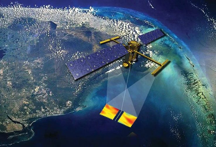
The magnitude 9.1 Sumatra earthquake generated a tsunami killing 230,000 people across 14 countries. TOPEX/Poseidon and Jason-1 satellites happened to pass overhead during the event, detecting 60-cm waves in deep ocean—the first-ever satellite tsunami observation. But processing wasn't trivial, signal-to-noise was poor, and the satellites only captured thin 1D lines across the tsunami's path, missing the full picture.

Outcome

Short term: The detection came too late to save lives but proved satellites could theoretically observe tsunamis.

Long term: 
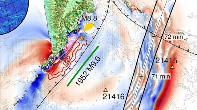
Triggered massive expansion of DART buoy network from 6 to 60 stations globally and spurred research into satellite-based tsunami detection.

Why It's Relevant

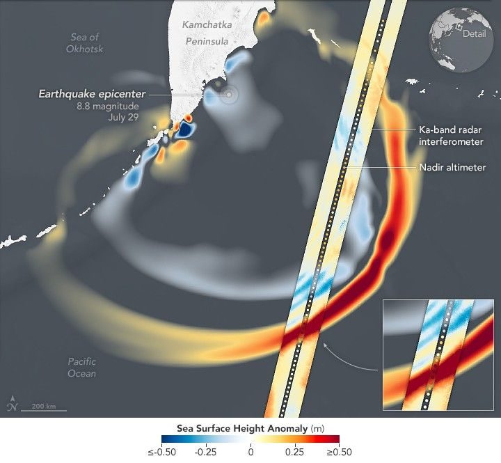
Shows the 20-year evolution from accidental detection to SWOT's purpose-built 2D imaging—but also highlights the persistent challenge of turning space observations into fast warnings.

2011 Tohoku Tsunami Satellite Observations

March 11, 2011

What Happened

The magnitude 9.0 Japan earthquake killed 18,000 people and triggered the Fukushima nuclear disaster. Three satellites observed the tsunami front, marking the first time multiple satellites captured the same event—one recorded wave heights twice as high as the others, revealing how tsunamis merge over ocean ridges. NASA's Tony Song discovered this 'merging tsunami' phenomenon doubled the wave's intensity, challenging conventional tsunami formation theory based solely on vertical seafloor uplift.

Outcome

Short term: NOAA's improved warning system—expanded seismic networks, W-phase magnitude calculations within 25 minutes—issued alerts in 3 minutes and saved lives.

Long term: Became the best-recorded subduction quake ever, proving satellite data's scientific value but also exposing limitations of 1D altimetry for understanding wave complexity.

Why It's Relevant

The Kamchatka event continues this pattern: each major tsunami teaches us that previous models were oversimplified, and better observations reveal behaviors we didn't know existed.

Development of DART Tsunami Buoys (1995-2003)

1995-2003

What Happened

After devastating 1990s tsunamis, NOAA's Pacific Marine Environmental Laboratory spent eight years developing Deep-ocean Assessment and Reporting of Tsunami (DART) buoys. The system uses seafloor pressure sensors connected via acoustic modem to surface buoys that relay data through satellites. Multiple designs failed before an operational prototype emerged in October 2003. The first experimental forecast came in November 2003, correctly predicting a 0.3-meter Hawaiian tsunami and avoiding unnecessary evacuation.

Outcome

Short term: Proved real-time deep-ocean tsunami detection was possible, solving a problem that had stymied scientists for decades.

Long term: DART became the backbone of global tsunami warning systems, but with inherent limitations: high false-alarm thresholds, ~5% data loss, coverage gaps, and vulnerability to rough seas.

Why It's Relevant

SWOT doesn't replace DART—it complements it by filling spatial gaps and revealing wave behavior buoys can't see. The question is whether satellites can overcome their own limitations (revisit time, data latency) to become operational tools rather than just research instruments.